Topography Maps
Watch the video
Case Studies
Save time and money.
Make informed decisions.
Unrivaled precision. Our high-resolution, detailed topography maps, 2D and 3D maps capture every contour of your project. Precise within 2-5 cm. Ready for use in AutoDesk and popular Architecture, Engineering & Construction software.
We have saved our clients millions of pesos by preventing potential errors that were missed by other topographers.
Our topography and elevation maps empower professionals across industries, from agriculture to construction and real-estate, with the insights needed to optimize workflows, reduce costs, and minimize environmental impact. Elevate your decision-making process with data-driven intelligence. Ready in as little as 48 hours.
2D Map Files

-
GeoTIFF Orthomosaic Map
-
GeoTIFF Elevation Map
-
GeoTIFF Raw Elevation Values (DEM)
-
Plant Health GeoTIFF
-
Raw Elevation Values (DTM)
-
Contour DXF (AutoCAD): 0,25m 0,5m 1,0m 1,5m
-
Contour SHP (Shapefile): 0,25m 0,5m 1,0m 1,5m
-
DWG file with perimeter and coordinates
All files are formatted for your preferred project coordinate systems and maps include a quality assessment report to ensure accuracy.

Archivos de Modelos 3D
-
Point Cloud LiDAR data Exchange (.las)
-
Point Cloud ASCII xyzrgb (.xyz)
-
3D Model (.obj)
-
Contour DXF (AutoCAD): 0,25m 0,5m 1,0m 1,5m
-
Contour SHP (Shapefile): 0,25m 0,5m 1,0m 1.5m
-
Sample:

-
GeoTIFF 2D Raw Elevation Values (DEM)
-
GeoTIFF 2D Plant Health
-
Raw Elevation Values Digital Terrain Model (DTM)
-
Contours 2D y 3D SHP (Shapefile): 0,25 m, 0,5 m, 1,0 m 1,5 m
-
Point Cloud LiDAR data exchange (.las)
-
Point Cloud ASCII xyzrgb (.xyz)
-
3D Model (.obj)
-
Quality and Accuracy Report
-
Annotation Report
-
Instructions to import into AutoCAD
-
2D High Resolution Print Files to Scale
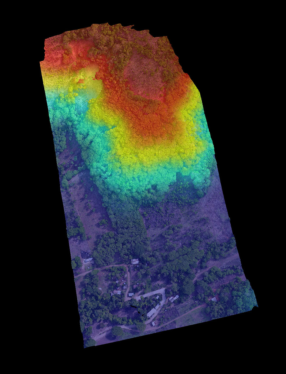
This land was scanned in order to determine how many lots could be created after building a road for access, and to use for presentation purposes. The unconventional shape and the change in elevation made it difficult for the owners to visualize its potential. Our maps generated an exact replica with precise measurements, along with a report regarding potential lot sizes and value of each lot.
The asking price for 4,500 m2 was $4,000,000 MXN and it was sitting on the market for years. Lotification is popular in this area. With our maps and reports we showed the client that they could divide the land into 18 lots and make $6,468,950 MXN, minus the nominal cost of building a road. A difference of $2,468,950 MXN.
Area Scanned: 6.59 Hectares
Area of Interest: 4,500 m²
Coordinates: WGS 84/ UTM Zona 14N
RMSE: 2.86cm
Archivos
Overview:
Turnaround Time: 2 Días
(haga clic en cada archivo para descargar)
Large & Complex Land:
Mediam Land: 1,000 m² - 5 Hectares
$15,000 MXN
Perfect for residential and small hotels
Average turnaround time: 2-5 business days$20,000 MXN flat rate for up to 1 hectare
Additional $1.50 MXN per m² for lots larger than 1 hectare
Exemple: $35,381 for a 20,254 m² lot
Average turnaround time: 5 business days
Custom Pricing
For land more than 5 hectares or smaller land with complex terrain, we discuss your needs, budget and timelines to create a customized plan just for you, ensuring you get exactly what you need for your project's success.
This includes a reduced cost per square meter at bulk rates and delivering files in phases in accordance with your project plans and timelines.
Small Land: Projects Under 1,000 m²
Our pricing is structured according to the size of your land, ensuring that we can accommodate everyone at every stage of development. All pricing plans include all files listed in the "What's Included" section above, ensuring that you have everything you need to plan with confidence.
Prices exclude additional consulting. Consulting for detailed reports start at $1,000 MXN/ hour and is quoted on a case by case basis depending on the scope of the project.


8 hectares of usable land and 38 hectares of surrounding space in Los Naranjos. Our focus: elevation for flood zones and tree preservation for green space, vital for planning a running path and athletic facilities.
Coming Soon...
RUNNING PATH FLOOD ZONES

For beachfront casa construction in La Barra, precise 2D and 3D elevation maps were essential to the builder. Swells and rising water levels from the beach and lagoon made accuracy crucial for planning. Turnaround time: 3 Days.
Coming Soon..
CASA
TIMTAVIO
Our detailed maps and models helped our client envision their community, saving millions in road placement and lotification costs, while preserving greenspace compared to their original plans.
Coming Soon...
CONSERVING
GREENSPACES

COMMUNITY PLANNING
Our client listed an unconventional space for below market value. Our data unveiled its true selling potential, identifying an additional $2.5 million MXN in market value at the time of map and model creation.
Coming Soon..
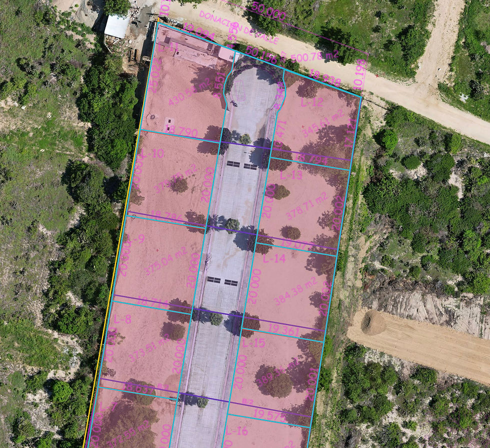
VERIFYING PROPERTY LINES
By overlaying geo-referenced plans, we assisted our client in verifying the total area of their development, identifying where property lines were encroached upon and pinpointing errors that could lead to confusion in future construction.
Coming Soon...
RISK
ASSESSMENT
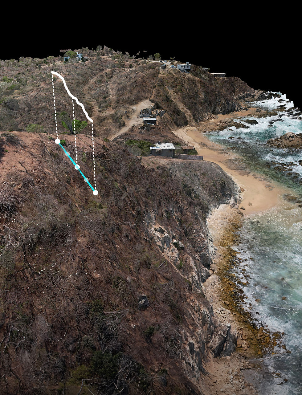
Given the steep inclines and diverse coastal terrain, our client cross-referenced original plans to identify safe planning. Our maps and models revealed errors and hazards, allowing the client to plan their $100 million MXN community without error.
Coming soon..
Conatact
HOW TO GET
YOUR MAPS
Choose from our 3 straightforward pricing options tailored to your land size. Select the day that you need your files and complete our quick information request form. Our team will confirm your reservation within 1 business day and schedule a property inspection.
Book Now
We'll assess your property's readiness for mapping through a comprehensive inspection. Together, we'll finalize details, including square meters and any necessary preparations. Following this, your official quote will be provided, requiring a 50% deposit for scheduling.
Property Inspection
Upon receipt of the deposit, we'll proceed with scanning your property, adhering to the agreed timeline. Typically, turnaround time is less than a week. Once completed, we'll upload the files to our server, providing a quality and accuracy report. We'll then schedule a final meeting for file walkthrough before activating the download link upon receipt of the remaining 50% payment.
Property Scan & File Delivery
Clients